Chardham Yatra is not just a trip. It is a dream for many people in India. Every year, lakhs of travellers wish to visit Yamunotri, Gangotri, Kedarnath, and Badrinath. These four holy places are in Uttarakhand, high in the mountains. The journey is long. Roads are narrow at some places. The weather can change fast. So before you start, it feels safe when you know the right way to go.
That is the reason people look for a clear Chardham yatra route map. When you have the route in front of you, you can plan your stops, stay relaxed, and enjoy the trip. A map also helps elders and families who worry about the road. They can see the full path on paper or on a phone and be sure they are moving right.
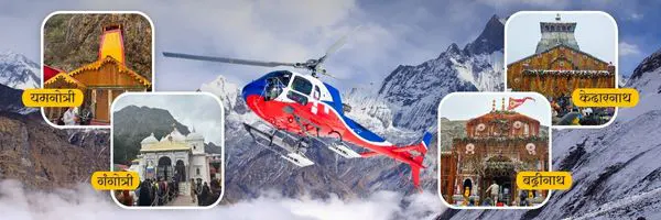
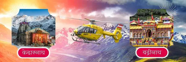
In most cases, the yatra begins from Haridwar or Rishikesh. Pilgrims take the Chardham yatra route map by road and go first to Yamunotri. After Yamunotri, the road leads to Gangotri. Then the journey shifts to Kedarnath and ends at Badrinath. Each dham has its own route. Some parts need short walks or a Chardham Yatra by helicopter, while the rest is by road.
Here you will get all the information that you may think of before the journey. Simple map. Full route. Important towns in between. Small travel tips. Common doubts that come in mind. The goal of this guide is very clear. You should feel confident about the way. You should know where you go next. And you should enjoy the yatra more, without stress about the route. This is your route guide for darshan at the four sacred dhams. Read it with calm mind. It will make your Chardham Yatra easier and more blessed.
Chardham Yatra by Helicopter – 5N/6D Tour
- Duration
- 6 Days / 5 Night
Do Dham Yatra by Helicopter Tour Packages
- Duration
- Same Day
- 4 Days / 3 Night
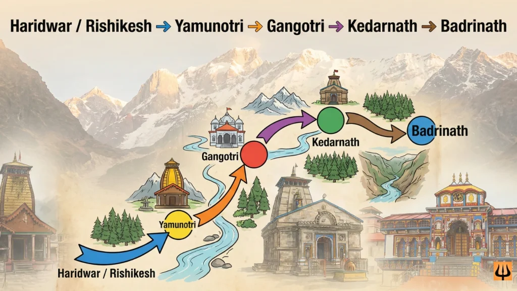
Char Dham Route: Yamunotri :: Gangotri :: Kedarnath :: Badrinath
The Chardham Yatra follows one fixed order. First Yamunotri, then Gangotri, next Kedarnath, and last Badrinath. This order is followed from many years. Pilgrims believe the journey should begin from the place of Maa Yamuna and then move to Maa Ganga. After taking blessings from the two holy rivers, the path leads next to Lord Shiva in Kedarnath. The yatra completes in Badrinath with the darshan of Lord Vishnu. This is the full flow of faith shown clearly in Chardham yatra route map.
Most people start the yatra from Haridwar or Rishikesh. They travel by road using the char dham route map by road. Some parts of the journey are simple highways. Some parts are hill roads with sharp turns. But the view is beautiful everywhere. You see tall trees, small waterfalls, and many small towns on the way. Drivers who take yatris are used to these roads, so the travel stays safe as given in char dham yatra map details.
Yamunotri and Gangotri routes are mainly road travel. Kedarnath needs a trek from Gaurikund, unless someone takes a horse or helicopter. Badrinath is again a road route. Pilgrims who follow this order feel the trip stays smooth, and their energy stays balanced for the harder parts like Kedarnath.
Below is the simple route order most yatris follow:
Haridwar/Rishikesh → Yamunotri
Yamunotri → Gangotri
Gangotri → Kedarnath
Kedarnath → Badrinath
There are food stops and stay options in almost every big town on this path. The char dham route map with distance is very clear, and many signboards help you on the road. You also meet other yatris going to the same place, so you never feel alone. Following the correct char dham route map helps avoid confusion. It saves time and keeps the journey easy. And when the route is clear, your mind stays focused on prayer and blessings, not on worry. That is the true purpose of this guide — make your travel peaceful.
Gangotri Dham Route Map
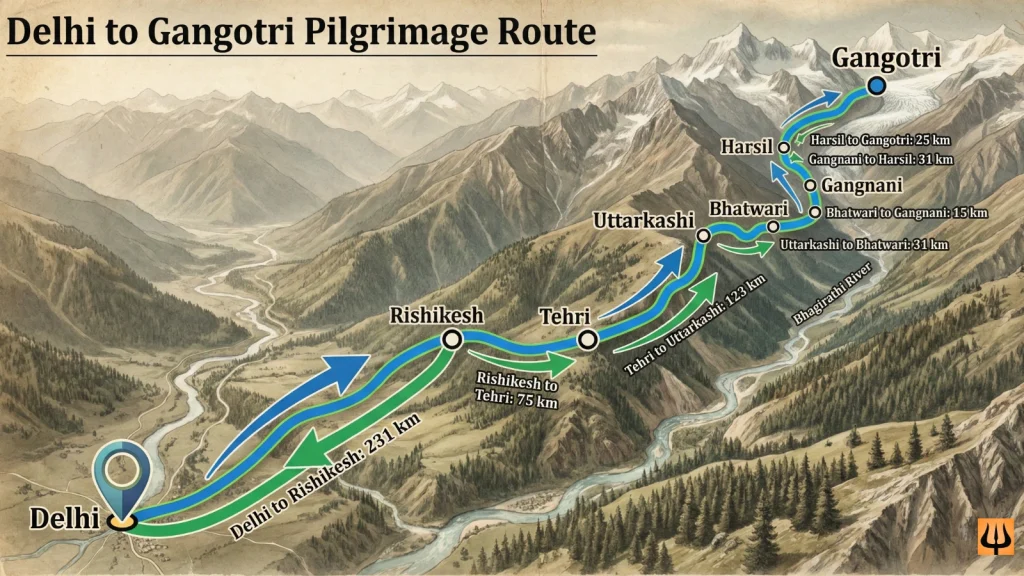
Gangotri is a place that fills your mind with calm, fresh air, and green hills. The ride to Gangotri is not too hard. Many yatris reach via road and that makes the trip gentle before the tougher parts of the yatra as shown in the Chardham yatra route map. The journey usually begins from a town like Uttarkashi or Harsil, depending on where you stay. The road winds along the river Bhagirathi. You will see water flowing beside the road almost the whole way. Mountains stand tall on both sides. The path bends again and again. Cars slow down at curves. Sometimes the road gets narrow. But people are helpful. Drivers show care. Local helpers guide you when needed, following the same char dham route map by road
On the way you see small shops, tea stalls, and fruit sellers. People stop for a quick cup of chai. Others stretch legs near river banks. Kids run around a little. Some elders sit quietly and enjoy the breeze. The sound of water, wind, and light chatter makes you forget the distance you travelled. When you come close to Gangotri town, snow peaks begin to show near the path. The air gets cooler. The smell of pine trees fills the lungs. The road becomes steeper. But you know you are close. Pilgrims start feeling joy. Their eyes shine. Because they remember — Ganga is ahead. This feeling is a major part of the char dham yatra map.
Finally the road ends near the temple area. After parking, many walk a little along stone steps to reach the temple gate. There is no big climb now. That makes it easier for families to visit. You walk, take a deep breath, and see the holy river emerge from the glacier close by. The beauty is calm and pure.
Having a simple char dham route map helps you see every curve, every river bend, every small town before Gangotri. You travel with less worry. You see the mountains with full heart. You reach Gangotri safe, with hope in your heart and respect in your mind.
Destination | Distance |
Delhi to Rishikesh | 231 kms |
Rishikesh to Tehri | 75 kms |
Tehri to Uttarkashi | 123 kms |
Uttarkashi to Bhatwari | 31 kms |
Bhatwari to Gangnani | 15 kms |
Gangnani to Harsil | 31 kms |
Harsil to Gangotri | 25 kms |
Yamunotri Dham Route Map
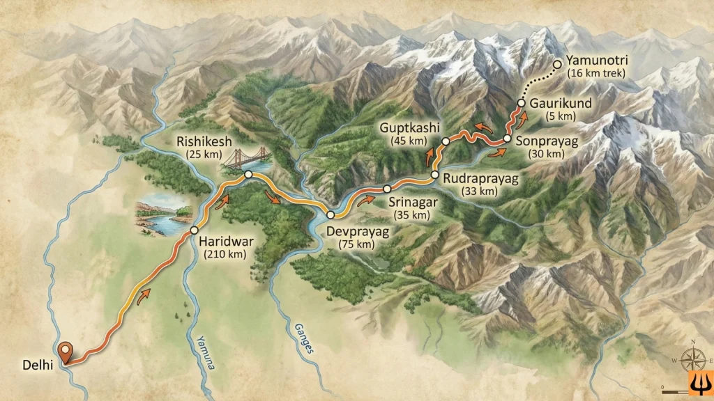
Yamunotri is the first dham of the Chardham Yatra. People feel happy to begin their journey here because it feels like a strong and pure start. The road to Yamunotri takes you through small mountain towns, quiet forests, and views that make you forget your phone. The main road brings you to a place called Janki Chatti. Cars, buses, and taxis stop here only. The yatra to the temple moves ahead on foot from this point. The walk is not flat. It goes up and up. But the path is clear. Many other pilgrims walk with you. Some sing bhajans. Some walk silently while watching the hills.
There are ponies too. And palki service for those who cannot climb. Many elders choose this so they can reach the temple without stress. You also see tea stalls, fruit carts, and small shops with raincoats and walking sticks. People take a break when legs feel tired. Nobody pushes you to go fast. Everyone moves at their own speed as shown in the Chardham yatra route map by road. The river Yamuna flows nearby. You can hear the sound of water on the stones. It feels nice. Nature keeps you company. Trees cover the path at many places. The cool wind touches your face. It feels like the mountain is wishing you a good yatra. All this is a beautiful part of the char dham in map experience.
The last part of the climb may feel a little hard. But the moment Yamunotri Temple appears in sight, your steps become lighter on their own. You see prayer flags flying. You hear the bell. A smile comes on its own.
Having a Chardham yatra route map by road makes the road section simple. You know the way till Janki Chatti. And once you start walking, the crowd itself becomes the guide. You move with faith and reach Maa Yamuna’s temple with joy.
Destination | Distance |
Delhi to Haridwar | 210 km |
Haridwar to Rishikesh | 25 kms |
Rishikesh to Devprayag | 75 kms |
Devprayag to Srinagar | 35 kms |
Srinagar to Rudraprayag | 33 kms |
Rudraprayag to Guptkashi | 45 kms |
Guptkashi to Sonprayag | 30 kms |
Sonprayag to Gaurikund | 5 kms |
Gaurikund to Kedarnath (Trek) | 16 km trek |
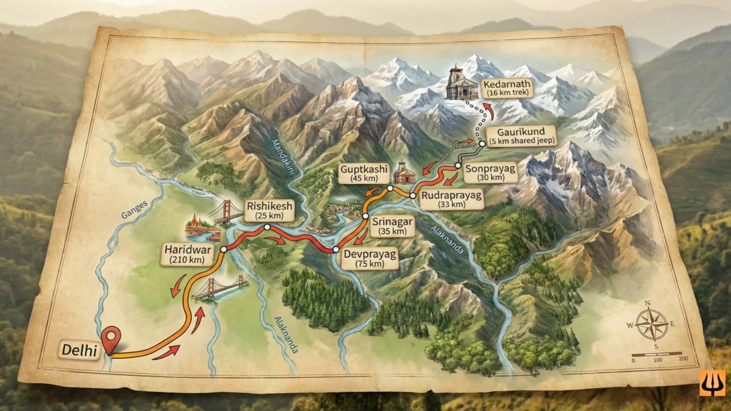
Kedarnath Dham Route Map
Kedarnath is the dham where everyone gets a little emotional. Maybe because the road is tough. Maybe because the feeling is strong. don’t know. But people say Baba Kedarnath pulls you in his own way, and the Chardham yatra route map shows how special this path is. To reach here, the road first takes you to Sonprayag. Cars stop there. The place is always busy with yatris and jeeps. You wait for your turn to go up to Gaurikund. The jeep ride is short. You hear the river right next to the road. You also see shops everywhere. People buy small things like gloves or a stick for support, just like shown on the char dham road map.
From Gaurikund, the walk starts. That is the real route to Kedarnath. Some people walk slow. Some walk fast. Some sit for a tea break every one hour. Many talk to each other even if they met for the first time. The mountain has a way of making everyone friends, on this char dham yatra map route. There are ponies too. And men who carry doli. It helps elders and those who cannot walk long. And if someone wants to skip the trek, helicopters are also there from places like Phata. Not always, but mostly during season. All these options are also noted in many Chardham yatra route map by road details.
The river Mandakini walks with you almost the entire time. Sometimes you can see it. Sometimes only the sound reaches you. The air feels thin as you climb, but you don’t think much because the wish to reach the temple takes over everything else. When the temple shows up from far… that moment stays inside the heart. People cry. People smile. Everyone forgets the pain. You feel Baba has been waiting.
A simple chardham route map helps so much here. You know how many turns. How many rest points. And you move without fear. One step at a time. One small prayer in mind.
Destination | Distance |
Delhi to Haridwar | 210 km |
Haridwar to Rishikesh | 25 km |
Rishikesh to Devprayag | 75 km |
Devprayag to Srinagar | 35 km |
Srinagar to Rudraprayag | 33 km |
Rudraprayag to Guptkashi | 45 km |
Guptkashi to Sonprayag | 30 km |
Sonprayag to Gaurikund | 5 km (shared jeep) |
Gaurikund to Kedarnath (Trek) | 16 km trek |
Kedarnath NEW ROUTE after 2013 Flood | |
Gaurikund to Jungle Chatti | 4 kms |
Jungle Chatti to Bheembali | 3 kms |
Bheembali to Lincholi | 4 kms |
Lincholi to Kedarnath | 4 kms |
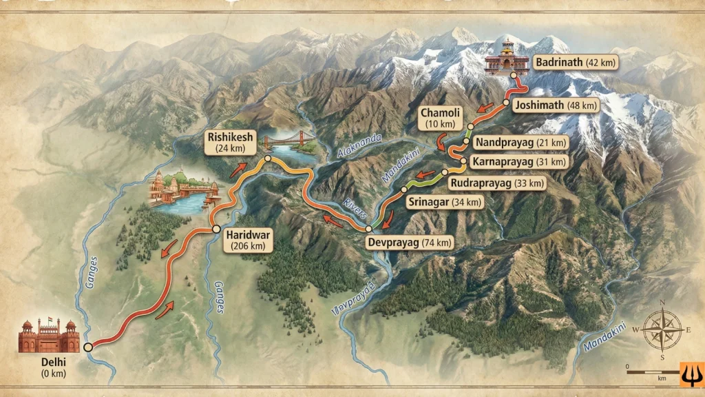
Badrinath Dham Route Map
Badrinath is the last dham in the Chardham Yatra. Many people say, “When we reach Badrinath, it feels like we completed something big in life.” This place is that special. The drive to Badrinath starts after Kedarnath darshan. Most travellers sleep in Guptkashi or Rudraprayag before moving ahead. It gives the body some rest. The next day feels fresh. The road is not flat. It is a mountain road. So sometimes the ride is slow. But it never feels boring. The Alaknanda river stays with you for a long time just like shown in the char dham route map with distance. You can hear the sound of water from your window. Small bridges come on the way. One hill goes down, another comes up. The weather also keeps changing. Cool air, warm sun, and then cool again.
There are important towns in between. Karnaprayag. Nandprayag. Many people stop for tea and look at the water where rivers meet. It gives a nice break from sitting in the car. You also pass many villages. Kids wave at the cars sometimes. The mountain life looks simple and sweet. All these stops are marked clearly in the Chardham yatra map.
Joshimath arrives before Badrinath. It is a big stop. You find shops, hotels, and a busy market here. If the road ahead has snow, travellers wait in Joshimath. But when the road is open, everyone gets excited because Badrinath is near. From Joshimath to Badrinath, the views become more beautiful. Snow peaks look closer. Some places have a light mist. It feels like nature is guiding you slowly to the temple. You reach the main town and the temple is at the center. The walk is short. No trek. Families feel happy here because everyone can go together for darshan.
Having the char dham road map in hand gives comfort. You know where you are going next. You know the names on the boards. You travel with confidence. And that makes the blessings feel even stronger.
Destination | Distance |
Delhi to Haridwar | 206 kms |
Haridwar to Rishikesh | 24 kms |
Rishikesh to Devprayag | 74 kms |
Devprayag to Srinagar | 34 kms |
Srinagar to Rudraprayag | 33 kms |
Rudraprayag to Karnaprayag | 31 kms |
Karnaprayag to Nandprayag | 21 kms |
Nandprayag to Chamoli | 10 kms |
Chamoli to Joshimath | 48 kms |
Joshimath to Badrinath | 42 kms |
Route Map for Char Dham Yatra
The Chardham Yatra starts from the plains and slowly takes you up into the high mountains. Most yatris begin their journey from Haridwar or Rishikesh. Both places are easy to reach by train, bus, or flight (Dehradun airport). From here, the real mountain road route starts.
The order of the route is very simple:
Haridwar / Rishikesh → Yamunotri → Gangotri → Kedarnath → Badrinath
This order is followed every year. It keeps the journey smooth. Energy stays balanced. And it matches the flow of prayers — first the holy rivers, then Lord Shiva, and then Lord Vishnu.
The road signboards show the way clearly. Drivers who take yatris know the route very well. You will pass many small towns, dhabas, and shops that help you rest and regain strength. Mobile network may not work in some places, so having a printed or saved Chardham yatra road route map gives peace of mind. Some people stop extra nights in between to rest or enjoy the mountains slowly. There is no rush. Everyone moves according to their health and comfort.
A clear char dham map with distance or route list helps you plan where to stay and how long each ride may take. It makes you feel prepared. You can mark your stops on the map and show your family too. It brings confidence to the group. And your focus stays on the holy journey, not on confusion about the road. A good char dham road route map is like a travel friend. It keeps you on the right path till the final darshan at Badrinath.
Destination | Distance |
Delhi to Rishikesh | 230 km |
Rishikesh to Yamunotri | 210 km + trek |
Yamunotri to Gangotri | 240 km |
Gangotri to Kedarnath | 260 km + trek |
Kedarnath to Badrinath | 200 km |
Badrinath to Delhi | 520–550 km |
Important Cities and Towns That Come During Chardham Yatra
During the Chardham Yatra, the road takes you through many towns that give you food, stay, and help. These places are not just stops. They are part of the journey. Each one has its own charm and importance shown in the Chardham yatra route map.
- Haridwar and Rishikesh
Most yatris start from here. You can buy warm clothes, medicines, rain jackets, and basic travel needs. Both places have big markets. The holy Ganga aarti blesses you with a beautiful start. These two cities stand clearly at the beginning of the char dham yatra map. - Barkot
On the way to Yamunotri. A calm town where people rest after a long drive. Many hotels and homestays are here. You see green hills all around. - Janki Chatti
The last road point for Yamunotri. It has pony service, palki, tea shops, small stalls with sticks and rain gear. The walk starts from here as shown in the char dham route map by road. - Uttarkashi
A main town in the mountains. It has many temples and ashrams. People stay here before going to Gangotri. You can refill fuel, buy woolens, and eat good food. - Harsil
Close to Gangotri. It is quiet and full of nature. Apple trees, pine forests, cold wind. A peaceful stay spot. - Guptkashi and Sonprayag
Important stops before Kedarnath. Sonprayag is where vehicles stop and jeeps take you to Gaurikund. Guptkashi has many stay options. - Gaurikund
Start of Kedarnath trek. Hot water springs and many supply shops are found here. This point is the beginning of the trek shown on the Chardham yatra map. - Rudraprayag
A big town at river confluence. Usually used as a night halt while moving between Kedarnath and Badrinath. - Joshimath
Last major town before Badrinath. Many yatris stay here if the weather changes. Auli is also close from here.
Along the whole char dham route map, these towns help with food, washrooms, medicine, and rest. You meet people from all parts of India here. Everyone is on the same journey, wishing each other a good yatra. These towns are like friends who support you on the road. They make sure you reach every dham safe and happy.